Trail Walking Brunoy - Menhirs de l'Yerres - Photo

Menhirs de l'Yerres

© OpenStreetMap contributors
Length
Length
11.6 km
Max alt
Max alt
97 m
Uphill gradient
Uphill gradient
125 m
Km-Effort
Km-Effort  
13.3 km
Min alt
Min alt
38 m
Downhill gradient
Downhill gradient
125 m
Boucle
Boucle
Yes
Creation date :
2018-04-17 13:51:54.251
Updated on :
2018-04-17 13:51:54.251

(0 Reviews)

Walking
Walking
2h52
Difficulty : Medium

Scan this QR Code to open this trail in the SityTrail application

FREE GPS app for hiking

Logo SityTrail SityTrail

IGN / Geographical institutes

Download SityTrail from the App Store Download SityTrail from Google Play

Logo SityTrail SityTrail Plus

The world is yours!

Download SityTrail from the App Store Download SityTrail from Google Play Download SityTrail on Huawei AppGallery

About

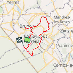
Trail Walking of 11.6 km to be discovered at Ile-de-France, Essonne, Brunoy. This trail is proposed by dmatignon.

Description

Boucle partant de la forêt de Sénart, et longeant l'Yerres où on peut découvrir plusieurs menhirs dont certains sont dans la rivière.

Elevation profile

Points of interest

Point of interest Boussy-Saint-Antoine - MENHIR de la PIERRE FITTE - Photo
dmatignon
BOUSSY-SAINT-ANTOINE 
Point of interest Boussy-Saint-Antoine - MOULIN de ROCHOPT - Photo
dmatignon
BOUSSY-SAINT-ANTOINE 
Point of interest Brunoy - MENHIR
dmatignon
Point of interest Épinay-sous-Sénart - LAVOIR XVIIIè siècle - Photo
dmatignon
ÉPINAY-SOUS-SÉNART 
Point of interest Brunoy - VIADUC d'EPINAY - Photo
dmatignon

Positioning

Country:
France
Region :
Ile-de-France
Department/Province :
Essonne
Municipality :
Brunoy
Location:
Unknown
Start:(UTM)
463271 ; 5392170 (31U) N.


Close
My subscriptions