


vassieux col

JACQUES.FUMAT
User
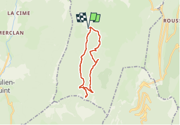

Length
12.3 km

Max alt
1380 m

Uphill gradient
300 m
Km-Effort
16.3 km

Min alt
1165 m

Downhill gradient
302 m
Boucle
Yes
Creation date :
2018-04-17 14:16:10.639
Updated on :
2018-04-17 14:16:10.639
3h50
Difficulty : Unknown

FREE GPS app for hiking
 SityTrail
IGN / Geographical institutes
SityTrail Plus
The world is yours!
About
Trail Other activity of 12.3 km to be discovered at Auvergne-Rhône-Alpes, Drôme, Vassieux-en-Vercors. This trail is proposed by JACQUES.FUMAT.
Description
raquettes
Positioning
Country:
France
Region :
Auvergne-Rhône-Alpes
Department/Province :
Drôme
Municipality :
Vassieux-en-Vercors
Location:
Unknown
Start:(Dec)
Start:(UTM)
686106 ; 4970663 (31T) N.
Comments