Trail Walking Monnières - Monnières sud-est - Photo
 TEFFRA
TEFFRA

User

© OpenStreetMap contributors
Length
Length
9.2 km
Max alt
Max alt
57 m
Uphill gradient
Uphill gradient
79 m
Km-Effort
Km-Effort  
10.3 km
Min alt
Min alt
18 m
Downhill gradient
Downhill gradient
80 m
Boucle
Boucle
Yes
Creation date :
2018-04-17 14:23:33.202
Updated on :
2018-04-17 14:23:33.202

(0 Reviews)

Walking
Walking
2h16
Difficulty : Easy

Scan this QR Code to open this trail in the SityTrail application

FREE GPS app for hiking

Logo SityTrail SityTrail

IGN / Geographical institutes

Download SityTrail from the App Store Download SityTrail from Google Play

Logo SityTrail SityTrail World

The world is yours!

Download SityTrail from the App Store Download SityTrail from Google Play Download SityTrail on Huawei AppGallery

About

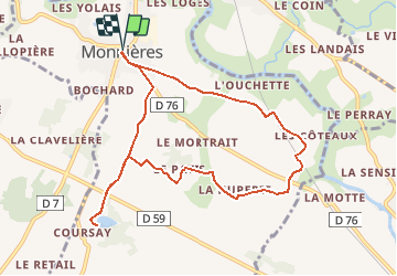
Trail Walking of 9.2 km to be discovered at Pays de la Loire, Loire-Atlantique, Monnières. This trail is proposed by TEFFRA.

Description

Point de RDV parking étang des Tuileries - Coursay

Elevation profile

Positioning

Country:
France
Region :
Pays de la Loire
Department/Province :
Loire-Atlantique
Municipality :
Monnières
Location:
Unknown
Start:(UTM)
624714 ; 5221133 (30T) N.

Trails nearby

Trail On foot La Haie-Fouassière - Entre Sèvre et Côteaux - Photo
On foot
PRO

On foot

Easy
La Haie-Fouassière, Pays de la Loire, Loire-Atlantique, France
9.3 km | 10.5 km-effort
2h 22min
Yes
Trail On foot Maisdon-sur-Sèvre - Soif de Nature - Photo
On foot
PRO

On foot

Easy
Maisdon-sur-Sèvre, Pays de la Loire, Loire-Atlantique, France
14.7 km | 17.1 km-effort
3h 53min
Yes
Trail Walking Maisdon-sur-Sèvre - Maisdon_Route de la soif - Photo
Walking
neoroll44

Walking

Medium
(1)
Maisdon-sur-Sèvre, Pays de la Loire, Loire-Atlantique, France
13.8 km | 16.1 km-effort
3h 30min
Yes
Trail Walking Saint-Fiacre-sur-Maine - vigne - Photo
Walking
bouchaudpl

Walking

Very easy
(1)
Saint-Fiacre-sur-Maine, Pays de la Loire, Loire-Atlantique, France
19.5 km | 23 km-effort
3h 41min
No
Trail Mountain bike Monnières - Sèvre et Maine - Monnières - Photo
Mountain bike
tracegps

Mountain bike

Difficult
(1)
Monnières, Pays de la Loire, Loire-Atlantique, France
34 km | 39 km-effort
2h 30min
Yes
Trail Walking Le Pallet - Le pallet - Photo
Walking
Lobin

Walking

Easy
Le Pallet, Pays de la Loire, Loire-Atlantique, France
8.8 km | 9.8 km-effort
316h 56min
Yes
Trail Other activity Monnières - Monnieres (44) - Photo
Other activity
bellicaud

Other activity

Easy
Monnières, Pays de la Loire, Loire-Atlantique, France
8 km | 9.1 km-effort
2h 2min
Yes
Trail Walking Monnières - Monnieres  Clisson - Photo
Walking
yves le sommer

Walking

Medium
Monnières, Pays de la Loire, Loire-Atlantique, France
10 km | 11.1 km-effort
2h 37min
No
Trail sport Maisdon-sur-Sèvre - 2023-03-12_09h35m53_SityTrail - 3559781 - chateauthebaud-01x03x23pluiematin- - Photo
sport
cyrillerandonneur

sport

Very easy
Maisdon-sur-Sèvre, Pays de la Loire, Loire-Atlantique, France
12.5 km | 14.7 km-effort
Unknown
Yes


Close
My subscriptions