


Kalmthout

festivalitis
User
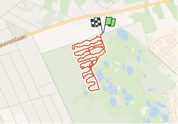

Length
5 km

Max alt
35 m

Uphill gradient
24 m
Km-Effort
5.3 km

Min alt
22 m

Downhill gradient
24 m
Boucle
Yes
Creation date :
2018-04-17 14:27:46.739
Updated on :
2018-04-17 14:27:46.739
2h04
Difficulty : Unknown

FREE GPS app for hiking
 SityTrail
IGN / Geographical institutes
SityTrail Plus
The world is yours!
About
Trail Other activity of 5 km to be discovered at Flanders, Antwerp, Kalmthout. This trail is proposed by festivalitis.
Positioning
Country:
Belgium
Region :
Flanders
Department/Province :
Antwerp
Municipality :
Kalmthout
Location:
Kalmthout
Start:(Dec)
Start:(UTM)
603695 ; 5691873 (31U) N.
Comments