


Rennes GR 39 et PR

chasle
User
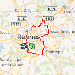

Length
24 km

Max alt
71 m

Uphill gradient
226 m
Km-Effort
27 km

Min alt
22 m

Downhill gradient
225 m
Boucle
Yes
Creation date :
2018-04-17 14:32:32.06
Updated on :
2018-04-17 14:32:32.06
5h54
Difficulty : Easy

FREE GPS app for hiking
 SityTrail
IGN / Geographical institutes
SityTrail Plus
The world is yours!
About
Trail Walking of 24 km to be discovered at Brittany, Ille-et-Vilaine, Rennes. This trail is proposed by chasle.
Positioning
Country:
France
Region :
Brittany
Department/Province :
Ille-et-Vilaine
Municipality :
Rennes
Location:
Quartiers Sud-Ouest
Start:(Dec)
Start:(UTM)
598262 ; 5326695 (30U) N.
Comments