


Bourganel par Nord de l'Autouroute

Seylinn
User
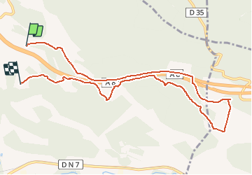

Length
10.9 km

Max alt
320 m

Uphill gradient
165 m
Km-Effort
13.1 km

Min alt
243 m

Downhill gradient
163 m
Boucle
No
Creation date :
2018-04-17 14:33:49.014
Updated on :
2018-04-17 14:33:49.014
1h40
Difficulty : Easy

FREE GPS app for hiking
 SityTrail
IGN / Geographical institutes
SityTrail Plus
The world is yours!
About
Trail Equestrian of 10.9 km to be discovered at Provence-Alpes-Côte d'Azur, Var, Tourves. This trail is proposed by Seylinn.
Positioning
Country:
France
Region :
Provence-Alpes-Côte d'Azur
Department/Province :
Var
Municipality :
Tourves
Location:
Unknown
Start:(Dec)
Start:(UTM)
738251 ; 4812776 (31T) N.
Comments