


Saignon Bories

kephas
User
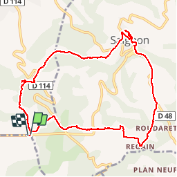

Length
10.8 km

Max alt
592 m

Uphill gradient
222 m
Km-Effort
13.8 km

Min alt
430 m

Downhill gradient
224 m
Boucle
Yes
Creation date :
2018-04-17 14:33:55.619
Updated on :
2018-04-17 14:33:55.619
3h02
Difficulty : Easy

FREE GPS app for hiking
 SityTrail
IGN / Geographical institutes
SityTrail Plus
The world is yours!
About
Trail Walking of 10.8 km to be discovered at Provence-Alpes-Côte d'Azur, Vaucluse, Saignon. This trail is proposed by kephas.
Description
Boucle agrémentée de beaux paysages et de magnifiques bories.
Visite de Saignon
Photos


Positioning
Country:
France
Region :
Provence-Alpes-Côte d'Azur
Department/Province :
Vaucluse
Municipality :
Saignon
Location:
Unknown
Start:(Dec)
Start:(UTM)
693259 ; 4857574 (31T) N.
Comments
Randonnée agréable