


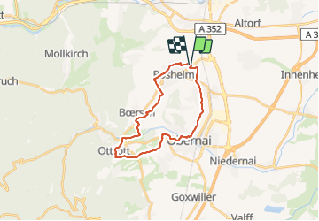
67 ROSHEIM OTROTT

LUTZMarc
User

Length
21 km

Max alt
289 m

Uphill gradient
270 m
Km-Effort
24 km

Min alt
171 m

Downhill gradient
269 m
Boucle
Yes
Creation date :
2018-04-17 14:36:32.992
Updated on :
2018-04-17 14:36:32.992
4h24
Difficulty : Easy

FREE GPS app for hiking
 SityTrail
IGN / Geographical institutes
SityTrail Plus
The world is yours!
About
Trail Walking of 21 km to be discovered at Grand Est, Bas-Rhin, Rosheim. This trail is proposed by LUTZMarc.
Description
Balade valonnee entre prés et vignes .
Resto l'Elsberg à Otrott
Positioning
Country:
France
Region :
Grand Est
Department/Province :
Bas-Rhin
Municipality :
Rosheim
Location:
Unknown
Start:(Dec)
Start:(UTM)
387941 ; 5373108 (32U) N.
Comments