


Ste Agnès

Thierryrando06
User

Length
5.4 km

Max alt
945 m

Uphill gradient
365 m
Km-Effort
10.3 km

Min alt
586 m

Downhill gradient
366 m
Boucle
Yes
Creation date :
2018-04-17 14:37:44.348
Updated on :
2018-04-17 14:37:44.348
2h15
Difficulty : Easy

FREE GPS app for hiking
 SityTrail
IGN / Geographical institutes
SityTrail Plus
The world is yours!
About
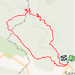
Trail Walking of 5.4 km to be discovered at Provence-Alpes-Côte d'Azur, Maritime Alps, Sainte-Agnès. This trail is proposed by Thierryrando06.
Positioning
Country:
France
Region :
Provence-Alpes-Côte d'Azur
Department/Province :
Maritime Alps
Municipality :
Sainte-Agnès
Location:
Unknown
Start:(Dec)
Start:(UTM)
375998 ; 4851077 (32T) N.
Comments