


Apprieu-2018

raymondfn
User
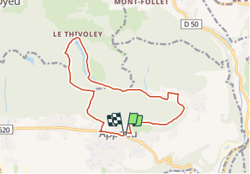

Length
7.8 km

Max alt
739 m

Uphill gradient
368 m
Km-Effort
12.7 km

Min alt
489 m

Downhill gradient
365 m
Boucle
Yes
Creation date :
2018-04-17 14:39:15.038
Updated on :
2022-03-26 22:48:25.946
2h38
Difficulty : Easy

FREE GPS app for hiking
 SityTrail
IGN / Geographical institutes
SityTrail Plus
The world is yours!
About
Trail Walking of 7.8 km to be discovered at Auvergne-Rhône-Alpes, Isère, Apprieu. This trail is proposed by raymondfn.
Positioning
Country:
France
Region :
Auvergne-Rhône-Alpes
Department/Province :
Isère
Municipality :
Apprieu
Location:
Unknown
Start:(Dec)
Start:(UTM)
696015 ; 5030312 (31T) N.
Comments
