


GRIGNAN 2018

collot
User
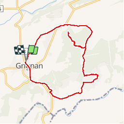

Length
9.3 km

Max alt
277 m

Uphill gradient
126 m
Km-Effort
11 km

Min alt
185 m

Downhill gradient
124 m
Boucle
Yes
Creation date :
2018-04-17 14:48:45.057
Updated on :
2018-04-17 14:48:45.057
3h24
Difficulty : Easy

FREE GPS app for hiking
 SityTrail
IGN / Geographical institutes
SityTrail Plus
The world is yours!
About
Trail Walking of 9.3 km to be discovered at Auvergne-Rhône-Alpes, Drôme, Grignan. This trail is proposed by collot.
Positioning
Country:
France
Region :
Auvergne-Rhône-Alpes
Department/Province :
Drôme
Municipality :
Grignan
Location:
Unknown
Start:(Dec)
Start:(UTM)
651959 ; 4920495 (31T) N.
Comments