Trail Walking Pierrevert - 
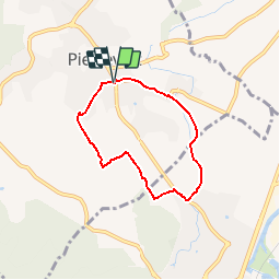
Le tour de Pierrevert - Photo
 liocol
liocol

User

© OpenStreetMap contributors
Length
Length
5.5 km
Max alt
Max alt
421 m
Uphill gradient
Uphill gradient
90 m
Km-Effort
Km-Effort  
6.7 km
Min alt
Min alt
355 m
Downhill gradient
Downhill gradient
87 m
Boucle
Boucle
Yes
Creation date :
2018-04-17 14:53:28.587
Updated on :
2018-04-17 14:53:28.587

(0 Reviews)

Walking
Walking
1h29
Difficulty : Very easy

Scan this QR Code to open this trail in the SityTrail application

FREE GPS app for hiking

Logo SityTrail SityTrail

IGN / Geographical institutes

Download SityTrail from the App Store Download SityTrail from Google Play

Logo SityTrail SityTrail Plus

The world is yours!

Download SityTrail from the App Store Download SityTrail from Google Play Download SityTrail on Huawei AppGallery

About

Trail Walking of 5.5 km to be discovered at Provence-Alpes-Côte d'Azur, Alpes-de-Haute-Provence, Pierrevert. This trail is proposed by liocol.

Description

Garez-vous sur le Parking du stade.
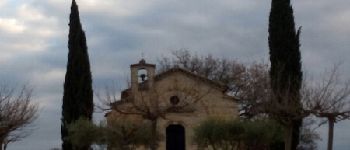
Boucle, via la Chapelle St Patrice.

Elevation profile

Photos

Points of interest

Point of interest Pierrevert - Point 1 - Photo
liocol
PIERREVERT 
Point of interest Pierrevert - Point 2 - Photo
liocol
PIERREVERT 
Point of interest Sainte-Tulle - Point 3  - Photo
liocol
SAINTE-TULLE 
Point of interest Sainte-Tulle - Point 4   - Photo
liocol
SAINTE-TULLE 
Point of interest Sainte-Tulle - Point 5  - Photo
liocol
SAINTE-TULLE 
Point of interest Sainte-Tulle - Point 8 - Photo
liocol
SAINTE-TULLE 
Point of interest Pierrevert - Point 9 - Photo
liocol
PIERREVERT 

Positioning

Country:
France
Region :
Provence-Alpes-Côte d'Azur
Department/Province :
Alpes-de-Haute-Provence
Municipality :
Pierrevert
Location:
Unknown
Start:(UTM)
721254 ; 4854353 (31T) N.


Close
My subscriptions