


FONTAINEBLEAU MELUN 20 KM

gemau77
User
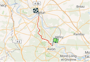

Length
20 km

Max alt
160 m

Uphill gradient
248 m
Km-Effort
24 km

Min alt
51 m

Downhill gradient
278 m
Boucle
No
Creation date :
2019-03-18 15:02:57.066
Updated on :
2020-09-07 16:49:05.946
5h02
Difficulty : Unknown

FREE GPS app for hiking
 SityTrail
IGN / Geographical institutes
SityTrail Plus
The world is yours!
About
Trail Walking of 20 km to be discovered at Ile-de-France, Seine-et-Marne, Avon. This trail is proposed by gemau77.

Positioning
Country:
France
Region :
Ile-de-France
Department/Province :
Seine-et-Marne
Municipality :
Avon
Location:
Unknown
Start:(Dec)
Start:(UTM)
479716 ; 5362655 (31U) N.
Comments