


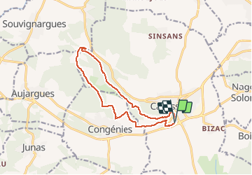
RP30 CALVISSON - CONGEDIES - Mas de Puech Long - A+R

jeff66
User


2h23
Difficulty : Medium

FREE GPS app for hiking
 SityTrail
IGN / Geographical institutes
SityTrail Plus
The world is yours!
About
Trail Walking of 13.3 km to be discovered at Occitania, Gard, Calvisson. This trail is proposed by jeff66.
Description
RP30 CALVISSON - parking ancienne gare - Chemin des côtes - roc mort - Mas de la treille - cabane du Capellan - puech de Monceau - CONGENIES - combe de Bial - Laurisset - ch. d’Ales - DFCI C8 - la manade - le terme blanc - manade du Roc - Mas de puech long - Labadel - DFCI C9 - la Tirasse - clos de Sabatier - Chantale haute - déchèterie - carrières - chante perdrix - CALVISSON - traverse des clos - impasse apparent -rue gaston Lhoustau - gare - le 24.12.2017
Positioning
Comments