


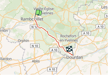
RAMBOUILLET > DOURDAN 22 KM

gemau77
User

Length
21 km

Max alt
178 m

Uphill gradient
196 m
Km-Effort
24 km

Min alt
111 m

Downhill gradient
240 m
Boucle
No
Creation date :
2019-03-18 15:02:48.448
Updated on :
2021-09-27 16:32:46.374
4h41
Difficulty : Unknown

FREE GPS app for hiking
 SityTrail
IGN / Geographical institutes
SityTrail Plus
The world is yours!
About
Trail Walking of 21 km to be discovered at Ile-de-France, Yvelines, Rambouillet. This trail is proposed by gemau77.
Positioning
Country:
France
Region :
Ile-de-France
Department/Province :
Yvelines
Municipality :
Rambouillet
Location:
Unknown
Start:(Dec)
Start:(UTM)
413909 ; 5388503 (31U) N.
Comments