


67 Geisweg Wangenbourg

LUTZMarc
User
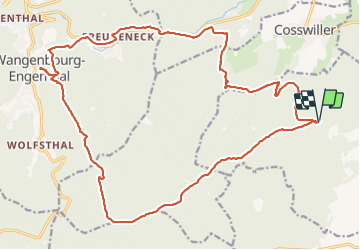

Length
24 km

Max alt
701 m

Uphill gradient
748 m
Km-Effort
34 km

Min alt
270 m

Downhill gradient
744 m
Boucle
Yes
Creation date :
2018-04-17 15:14:29.522
Updated on :
2018-04-17 15:14:29.522
5h57
Difficulty : Medium

FREE GPS app for hiking
 SityTrail
IGN / Geographical institutes
SityTrail Plus
The world is yours!
About
Trail Walking of 24 km to be discovered at Grand Est, Bas-Rhin, Westhoffen. This trail is proposed by LUTZMarc.
Description
Belle rando.
Resto l'AUBERGE DU CHATEAU à Wangenbourg.
Photos


Positioning
Country:
France
Region :
Grand Est
Department/Province :
Bas-Rhin
Municipality :
Westhoffen
Location:
Unknown
Start:(Dec)
Start:(UTM)
382410 ; 5385384 (32U) N.
Comments