


2018-25-03 Bondoufle 60km

Lucquiaud
User
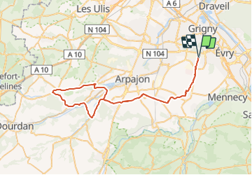

Length
63 km

Max alt
138 m

Uphill gradient
497 m
Km-Effort
69 km

Min alt
51 m

Downhill gradient
497 m
Boucle
Yes
Creation date :
2018-09-15 15:03:08.057
Updated on :
2018-09-15 15:03:08.066
4h06
Difficulty : Medium

FREE GPS app for hiking
 SityTrail
IGN / Geographical institutes
SityTrail Plus
The world is yours!
About
Trail Cycle of 63 km to be discovered at Ile-de-France, Essonne, Bondoufle. This trail is proposed by Lucquiaud.
Description
parcours de la randonnée 60 km cycliste organisée par le club de Bondoufle "Par Monts et Par Vaux"
Positioning
Country:
France
Region :
Ile-de-France
Department/Province :
Essonne
Municipality :
Bondoufle
Location:
Unknown
Start:(Dec)
Start:(UTM)
454175 ; 5385184 (31U) N.
Comments