
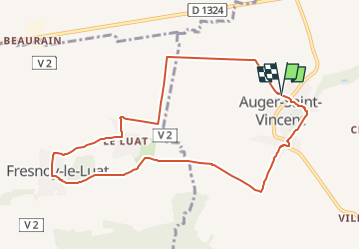
SM_AUGER-Saint-VINCENT_8.8Km
GOELE RANDO
Randonner avec bonne humeur et convivialité. (Inscription réservée uniquement aux animateurs de GOËLE RANDO)


2h07
Difficulty : Easy

FREE GPS app for hiking
 SityTrail
IGN / Geographical institutes
SityTrail Plus
The world is yours!
About
Trail Walking of 8.9 km to be discovered at Hauts-de-France, Oise, Auger-Saint-Vincent. This trail is proposed by GOELE RANDO.
Description
https://www.goelerando.fr/
DAMMARTIN en GOELE 77
Autour d'Auger, de Fresnoy-le-Luat et de Rosières, le pays du Valois entre plateau et coteaux..
Photos

Positioning
Comments