


Collobriéres - Menhirs de Lambert

soca
User
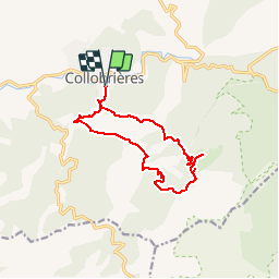

Length
13.4 km

Max alt
524 m

Uphill gradient
544 m
Km-Effort
21 km

Min alt
160 m

Downhill gradient
549 m
Boucle
Yes
Creation date :
2018-04-17 15:34:55.151
Updated on :
2018-04-17 15:34:55.151
4h21
Difficulty : Medium

FREE GPS app for hiking
 SityTrail
IGN / Geographical institutes
SityTrail Plus
The world is yours!
About
Trail Walking of 13.4 km to be discovered at Provence-Alpes-Côte d'Azur, Var, Collobrières. This trail is proposed by soca.
Positioning
Country:
France
Region :
Provence-Alpes-Côte d'Azur
Department/Province :
Var
Municipality :
Collobrières
Location:
Unknown
Start:(Dec)
Start:(UTM)
281563 ; 4790496 (32T) N.
Comments