


st caprés

mthomas30
User
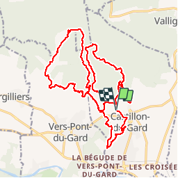

Length
27 km

Max alt
191 m

Uphill gradient
463 m
Km-Effort
34 km

Min alt
44 m

Downhill gradient
468 m
Boucle
Yes
Creation date :
2018-04-17 15:38:34.893
Updated on :
2018-04-17 15:38:34.893
3h15
Difficulty : Difficult

FREE GPS app for hiking
 SityTrail
IGN / Geographical institutes
SityTrail Plus
The world is yours!
About
Trail Mountain bike of 27 km to be discovered at Occitania, Gard, Castillon-du-Gard. This trail is proposed by mthomas30.
Positioning
Country:
France
Region :
Occitania
Department/Province :
Gard
Municipality :
Castillon-du-Gard
Location:
Unknown
Start:(Dec)
Start:(UTM)
624119 ; 4870251 (31T) N.
Comments