


Sur les traces de Manon des sourecs

soca
User
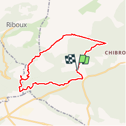

Length
15.8 km

Max alt
561 m

Uphill gradient
279 m
Km-Effort
19.5 km

Min alt
365 m

Downhill gradient
277 m
Boucle
Yes
Creation date :
2018-04-17 15:44:11.296
Updated on :
2018-04-17 15:44:11.296
4h13
Difficulty : Easy

FREE GPS app for hiking
 SityTrail
IGN / Geographical institutes
SityTrail Plus
The world is yours!
About
Trail Walking of 15.8 km to be discovered at Provence-Alpes-Côte d'Azur, Var, Signes. This trail is proposed by soca.
Positioning
Country:
France
Region :
Provence-Alpes-Côte d'Azur
Department/Province :
Var
Municipality :
Signes
Location:
Unknown
Start:(Dec)
Start:(UTM)
727105 ; 4795684 (31T) N.
Comments