


St Raphaêl - Pointe observatoire- cap Roux

soca
User
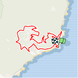

Length
10.9 km

Max alt
429 m

Uphill gradient
555 m
Km-Effort
18.3 km

Min alt
30 m

Downhill gradient
556 m
Boucle
Yes
Creation date :
2018-04-17 15:46:57.602
Updated on :
2018-04-17 15:46:57.602
3h56
Difficulty : Easy

FREE GPS app for hiking
 SityTrail
IGN / Geographical institutes
SityTrail Plus
The world is yours!
About
Trail Walking of 10.9 km to be discovered at Provence-Alpes-Côte d'Azur, Var, Saint-Raphaël. This trail is proposed by soca.
Positioning
Country:
France
Region :
Provence-Alpes-Côte d'Azur
Department/Province :
Var
Municipality :
Saint-Raphaël
Location:
Unknown
Start:(Dec)
Start:(UTM)
331518 ; 4812829 (32T) N.
Comments