La Gineste - Le Mont Puget

soca
User
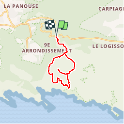

Length
11.5 km

Max alt
554 m

Uphill gradient
559 m
Km-Effort
18.9 km

Min alt
262 m

Downhill gradient
556 m
Boucle
Yes
Creation date :
2018-04-17 15:49:41.572
Updated on :
2018-04-17 15:49:41.572
4h07
Difficulty : Medium

FREE GPS app for hiking
 SityTrail
IGN / Geographical institutes
SityTrail Plus
The world is yours!
About
Trail Walking of 11.5 km to be discovered at Provence-Alpes-Côte d'Azur, Bouches-du-Rhône, Marseille. This trail is proposed by soca.
Positioning
Country:
France
Region :
Provence-Alpes-Côte d'Azur
Department/Province :
Bouches-du-Rhône
Municipality :
Marseille
Location:
9th Arrondissement
Start:(Dec)
Start:(UTM)
699478 ; 4790395 (31T) N.
Comments