


SAINT SIMEON 2

daniel77
User
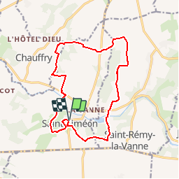

Length
14.5 km

Max alt
158 m

Uphill gradient
219 m
Km-Effort
17.4 km

Min alt
79 m

Downhill gradient
218 m
Boucle
Yes
Creation date :
2018-04-17 15:54:56.975
Updated on :
2018-04-17 15:54:56.975
3h46
Difficulty : Medium

FREE GPS app for hiking
 SityTrail
IGN / Geographical institutes
SityTrail Plus
The world is yours!
About
Trail Walking of 14.5 km to be discovered at Ile-de-France, Seine-et-Marne, Saint-Siméon. This trail is proposed by daniel77.
Positioning
Country:
France
Region :
Ile-de-France
Department/Province :
Seine-et-Marne
Municipality :
Saint-Siméon
Location:
Unknown
Start:(Dec)
Start:(UTM)
514941 ; 5405079 (31U) N.
Comments