


Sourcieux-Les-Mines (18,5 km-D.688)

Thomasdanielle
User

Length
18.6 km

Max alt
773 m

Uphill gradient
718 m
Km-Effort
28 km

Min alt
321 m

Downhill gradient
714 m
Boucle
Yes
Creation date :
2018-04-17 16:19:42.304
Updated on :
2018-04-17 16:19:42.304
5h01
Difficulty : Medium

FREE GPS app for hiking
 SityTrail
IGN / Geographical institutes
SityTrail Plus
The world is yours!
About
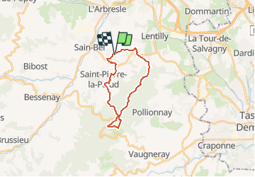
Trail Walking of 18.6 km to be discovered at Auvergne-Rhône-Alpes, Rhône, Sourcieux-les-Mines. This trail is proposed by Thomasdanielle.
Description
A/D Parking vers Eglise
18,5 km - D. 688
Pique-nique au col de la Luère après 8,5 km de marche (tables)
Positioning
Country:
France
Region :
Auvergne-Rhône-Alpes
Department/Province :
Rhône
Municipality :
Sourcieux-les-Mines
Location:
Unknown
Start:(Dec)
Start:(UTM)
626226 ; 5073652 (31T) N.
Comments