


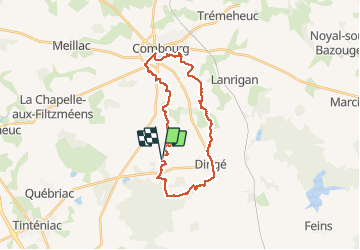
17.01.2018 - DINGE A COMBOURG

babeth35
User

Length
25 km

Max alt
110 m

Uphill gradient
219 m
Km-Effort
28 km

Min alt
31 m

Downhill gradient
217 m
Boucle
Yes
Creation date :
2018-04-17 16:22:55.749
Updated on :
2020-07-20 15:08:26.301
7h00
Difficulty : Medium

FREE GPS app for hiking
 SityTrail
IGN / Geographical institutes
SityTrail Plus
The world is yours!
About
Trail Walking of 25 km to be discovered at Brittany, Ille-et-Vilaine, Dingé. This trail is proposed by babeth35.
Positioning
Country:
France
Region :
Brittany
Department/Province :
Ille-et-Vilaine
Municipality :
Dingé
Location:
Unknown
Start:(Dec)
Start:(UTM)
592692 ; 5357003 (30U) N.
Comments