


Fontainebleau les Hautes Plaines

dmatignon
User
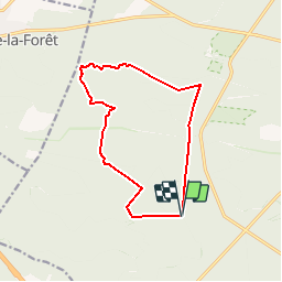

Length
12.2 km

Max alt
146 m

Uphill gradient
131 m
Km-Effort
13.9 km

Min alt
89 m

Downhill gradient
131 m
Boucle
Yes
Creation date :
2018-04-17 16:33:10.275
Updated on :
2018-04-17 16:33:10.275
2h50
Difficulty : Medium

FREE GPS app for hiking
 SityTrail
IGN / Geographical institutes
SityTrail Plus
The world is yours!
About
Trail Walking of 12.2 km to be discovered at Ile-de-France, Seine-et-Marne, Fontainebleau. This trail is proposed by dmatignon.
Positioning
Country:
France
Region :
Ile-de-France
Department/Province :
Seine-et-Marne
Municipality :
Fontainebleau
Location:
Unknown
Start:(Dec)
Start:(UTM)
472100 ; 5358104 (31U) N.
Comments