Trail Walking Château-Gontier-sur-Mayenne - Azé - Château-Gontier - Photo
© OpenStreetMap contributors
Length
Length
18 km
Max alt
Max alt
82 m
Uphill gradient
Uphill gradient
168 m
Km-Effort
Km-Effort  
20 km
Min alt
Min alt
23 m
Downhill gradient
Downhill gradient
167 m
Boucle
Boucle
Yes
Creation date :
2018-04-17 16:48:49.832
Updated on :
2018-04-17 16:48:49.832

(0 Reviews)

Walking
Walking
5h00
Difficulty : Medium

Scan this QR Code to open this trail in the SityTrail application

FREE GPS app for hiking

Logo SityTrail SityTrail

IGN / Geographical institutes

Download SityTrail from the App Store Download SityTrail from Google Play

Logo SityTrail SityTrail World

The world is yours!

Download SityTrail from the App Store Download SityTrail from Google Play Download SityTrail on Huawei AppGallery

About

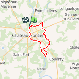
Trail Walking of 18 km to be discovered at Pays de la Loire, Mayenne, Château-Gontier-sur-Mayenne. This trail is proposed by neoroll44.

Description

Le chemin de marche-pied depuis le camping.

Elevation profile

Positioning

Country:
France
Region :
Pays de la Loire
Department/Province :
Mayenne
Municipality :
Château-Gontier-sur-Mayenne
Location:
Azé
Start:(UTM)
671916 ; 5300949 (30T) N.

Trails nearby

Trail Walking Fromentières - Chatrau Gontier - Photo
Walking
Axelloceane

Walking

Medium
Fromentières, Pays de la Loire, Mayenne, France
7.6 km | 8.9 km-effort
2h 0min
Yes
Trail Walking Château-Gontier-sur-Mayenne - Circuit du Moulinet au départ de Bazouges (n°1) - Photo
Walking
neoroll44

Walking

Medium
Château-Gontier-sur-Mayenne, Pays de la Loire, Mayenne, France
8.9 km | 10.3 km-effort
2h 20min
Yes
Trail Cycle Château-Gontier-sur-Mayenne - VOIE VERTE CHATEAU-GONTIER – SEGRÉ - Photo
Cycle
neoroll44

Cycle

Easy
Château-Gontier-sur-Mayenne, Pays de la Loire, Mayenne, France
23 km | 25 km-effort
1h 30min
No
Trail Walking Château-Gontier-sur-Mayenne - Circuit des Perrettes - Photo
Walking
neoroll44

Walking

Medium
Château-Gontier-sur-Mayenne, Pays de la Loire, Mayenne, France
5.4 km | 6.6 km-effort
1h 30min
Yes
Trail Walking Château-Gontier-sur-Mayenne - st fort promenade - Photo
Walking
piquet

Walking

Very easy
Château-Gontier-sur-Mayenne, Pays de la Loire, Mayenne, France
6.9 km | 7.7 km-effort
1h 49min
Yes
Trail Mountain bike Château-Gontier-sur-Mayenne - F.ChateauGontierPontsDeCéJ5/14 - Photo
Mountain bike
francois58

Mountain bike

Very easy
Château-Gontier-sur-Mayenne, Pays de la Loire, Mayenne, France
82 km | 92 km-effort
5min
No
Trail Mountain bike Château-Gontier-sur-Mayenne - BandaDelCucu6 - Photo
Mountain bike
plevier

Mountain bike

Very easy
Château-Gontier-sur-Mayenne, Pays de la Loire, Mayenne, France
57 km | 64 km-effort
3h 40min
No
Trail Bicycle tourism Château-Gontier-sur-Mayenne - Vélofrancette - Tronçon 3 - Photo
Bicycle tourism
ves

Bicycle tourism

Very easy
Château-Gontier-sur-Mayenne, Pays de la Loire, Mayenne, France
145 km | 162 km-effort
Unknown
No
Trail Mountain bike Château-Gontier-sur-Mayenne - prepa 2 rando vtt chateau gontier sud - Photo
Mountain bike
brassier

Mountain bike

Very difficult
Château-Gontier-sur-Mayenne, Pays de la Loire, Mayenne, France
64 km | 72 km-effort
4h 58min
Yes


Close
My subscriptions