


Tourlaville 18.5 km

AMOURETTE
User
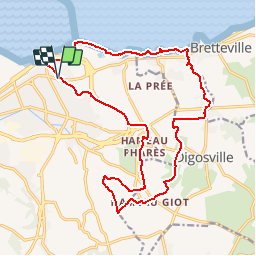

Length
18.5 km

Max alt
139 m

Uphill gradient
258 m
Km-Effort
22 km

Min alt
0 m

Downhill gradient
259 m
Boucle
Yes
Creation date :
2018-04-17 16:50:18.163
Updated on :
2019-03-28 12:09:19.964
4h45
Difficulty : Medium

FREE GPS app for hiking
 SityTrail
IGN / Geographical institutes
SityTrail Plus
The world is yours!
About
Trail Walking of 18.5 km to be discovered at Normandy, Manche, Cherbourg-en-Cotentin. This trail is proposed by AMOURETTE.
Description
AMAC
24 janvier 2015
Positioning
Country:
France
Region :
Normandy
Department/Province :
Manche
Municipality :
Cherbourg-en-Cotentin
Location:
Tourlaville
Start:(Dec)
Start:(UTM)
602789 ; 5500541 (30U) N.
Comments