


Chateauvallon Trail

vianneybenoist
User
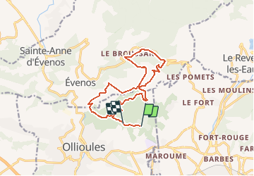

Length
17.3 km

Max alt
510 m

Uphill gradient
678 m
Km-Effort
26 km

Min alt
114 m

Downhill gradient
644 m
Boucle
No
Creation date :
2018-04-17 17:01:30.725
Updated on :
2018-04-17 17:01:30.725
2h00
Difficulty : Medium

FREE GPS app for hiking
 SityTrail
IGN / Geographical institutes
SityTrail Plus
The world is yours!
About
Trail Running of 17.3 km to be discovered at Provence-Alpes-Côte d'Azur, Var, Ollioules. This trail is proposed by vianneybenoist.
Positioning
Country:
France
Region :
Provence-Alpes-Côte d'Azur
Department/Province :
Var
Municipality :
Ollioules
Location:
Unknown
Start:(Dec)
Start:(UTM)
733927 ; 4781155 (31T) N.
Comments