


013 Ners Ales

MERMOZ33
User
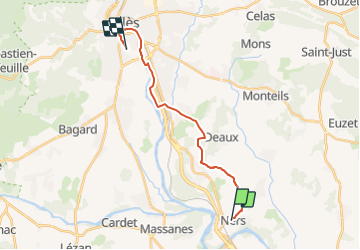

Length
17.6 km

Max alt
213 m

Uphill gradient
225 m
Km-Effort
21 km

Min alt
110 m

Downhill gradient
226 m
Boucle
No
Creation date :
2018-04-17 17:02:50.726
Updated on :
2018-04-17 17:02:50.726
4h29
Difficulty : Unknown

FREE GPS app for hiking
 SityTrail
IGN / Geographical institutes
SityTrail Plus
The world is yours!
About
Trail Walking of 17.6 km to be discovered at Occitania, Gard, Ners. This trail is proposed by MERMOZ33.
Positioning
Country:
France
Region :
Occitania
Department/Province :
Gard
Municipality :
Ners
Location:
Unknown
Start:(Dec)
Start:(UTM)
592770 ; 4875575 (31T) N.
Comments