


014 Ales Affenou

MERMOZ33
User
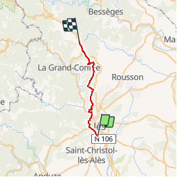

Length
21 km

Max alt
416 m

Uphill gradient
614 m
Km-Effort
29 km

Min alt
120 m

Downhill gradient
378 m
Boucle
No
Creation date :
2018-04-17 17:02:58.09
Updated on :
2018-04-17 17:02:58.09
6h12
Difficulty : Medium

FREE GPS app for hiking
 SityTrail
IGN / Geographical institutes
SityTrail Plus
The world is yours!
About
Trail Walking of 21 km to be discovered at Occitania, Gard, Alès. This trail is proposed by MERMOZ33.
Positioning
Country:
France
Region :
Occitania
Department/Province :
Gard
Municipality :
Alès
Location:
Unknown
Start:(Dec)
Start:(UTM)
586907 ; 4884842 (31T) N.
Comments