


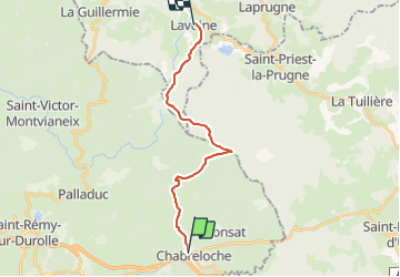
028 Chabreloche Lavoine

MERMOZ33
User

Length
16.9 km

Max alt
1204 m

Uphill gradient
651 m
Km-Effort
25 km

Min alt
618 m

Downhill gradient
456 m
Boucle
No
Creation date :
2018-04-17 17:05:16.825
Updated on :
2018-04-17 17:05:16.825
5h21
Difficulty : Medium

FREE GPS app for hiking
 SityTrail
IGN / Geographical institutes
SityTrail Plus
The world is yours!
About
Trail Walking of 16.9 km to be discovered at Auvergne-Rhône-Alpes, Puy-de-Dôme, Chabreloche. This trail is proposed by MERMOZ33.
Positioning
Country:
France
Region :
Auvergne-Rhône-Alpes
Department/Province :
Puy-de-Dôme
Municipality :
Chabreloche
Location:
Unknown
Start:(Dec)
Start:(UTM)
553873 ; 5080871 (31T) N.
Comments