


sete

philcll
User
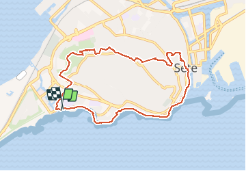

Length
9.5 km

Max alt
175 m

Uphill gradient
227 m
Km-Effort
12.5 km

Min alt
-1 m

Downhill gradient
223 m
Boucle
Yes
Creation date :
2018-04-17 17:11:25.744
Updated on :
2020-11-14 15:23:09.09
2h40
Difficulty : Easy

FREE GPS app for hiking
 SityTrail
IGN / Geographical institutes
SityTrail Plus
The world is yours!
About
Trail Walking of 9.5 km to be discovered at Occitania, Hérault, Sète. This trail is proposed by philcll.
Positioning
Country:
France
Region :
Occitania
Department/Province :
Hérault
Municipality :
Sète
Location:
Unknown
Start:(Dec)
Start:(UTM)
553824 ; 4804742 (31T) N.
Comments
Plusieurs problèmes de navigation, ça tire tout droit alors qu’il y a des habitations donc obligé de finir la montée en suivant la route sans trottoir