


dourdan

olivieraron
User
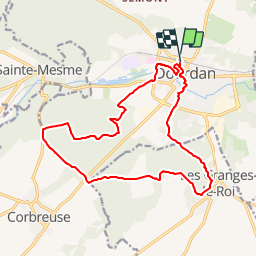

Length
17.7 km

Max alt
169 m

Uphill gradient
315 m
Km-Effort
22 km

Min alt
94 m

Downhill gradient
316 m
Boucle
Yes
Creation date :
2019-01-14 09:42:40.393
Updated on :
2025-02-10 08:16:32.738
3h20
Difficulty : Unknown

FREE GPS app for hiking
 SityTrail
IGN / Geographical institutes
SityTrail Plus
The world is yours!
About
Trail Other activity of 17.7 km to be discovered at Ile-de-France, Essonne, Dourdan. This trail is proposed by olivieraron.
Positioning
Country:
France
Region :
Ile-de-France
Department/Province :
Essonne
Municipality :
Dourdan
Location:
Unknown
Start:(Dec)
Start:(UTM)
426901 ; 5376052 (31U) N.
Comments