Trail Snowshoes Germ - Germ raquettes le 27 Janvier 2018-fait - Photo

Germ raquettes le 27 Janvier 2018-fait

 marmotte65
marmotte65

User GUIDE

© OpenStreetMap contributors
Length
Length
5.3 km
Max alt
Max alt
1614 m
Uphill gradient
Uphill gradient
284 m
Km-Effort
Km-Effort  
9.1 km
Min alt
Min alt
1343 m
Downhill gradient
Downhill gradient
283 m
Boucle
Boucle
Yes
Creation date :
2019-04-29 08:26:58.504
Updated on :
2020-03-23 09:21:48.421

(0 Reviews)

Snowshoes
Snowshoes
5h07
Difficulty : Medium

Scan this QR Code to open this trail in the SityTrail application

FREE GPS app for hiking

Logo SityTrail SityTrail

IGN / Geographical institutes

Download SityTrail from the App Store Download SityTrail from Google Play

Logo SityTrail SityTrail World

The world is yours!

Download SityTrail from the App Store Download SityTrail from Google Play Download SityTrail on Huawei AppGallery

About

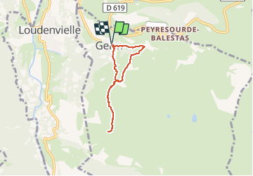
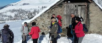
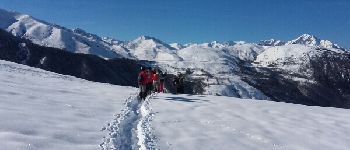
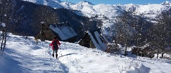
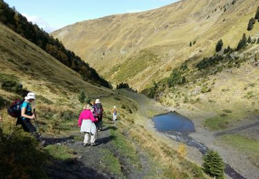
Trail Snowshoes of 5.3 km to be discovered at Occitania, Hautespyrenees, Germ. This trail is proposed by marmotte65.

Description

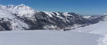
très jolie balade avec des paysages de neige top top .essayer de le faire en été.
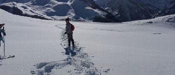
point culminant le pla de lasset à 1612m d'altitude en dessous de la station de payragudes. Un passage un peu délicat la traversée d'un talweg

Elevation profile

Photos

Points of interest

Point of interest Germ - pla de lasset - Photo
marmotte65
Point of interest Germ - pla de lasset - Photo
marmotte65
Point of interest Germ - pla de lasset - Photo
marmotte65
Point of interest Germ - cabane d'hierle - Photo
marmotte65
Point of interest Germ - granges de bederedes - Photo
marmotte65

Positioning

Country:
France
Region :
Occitania
Department/Province :
Hautespyrenees
Municipality :
Germ
Location:
Unknown
Start:(UTM)
289526 ; 4741074 (31T) N.

Trails nearby

Trail Walking Portet-de-Luchon - Du Col de Peyresourde au sommet du Pouyaué - Loudervielle - Photo
Walking
tracegps

Walking

Difficult
(1)
Portet-de-Luchon, Occitania, Haute-Garonne, France
9.9 km | 18.4 km-effort
4h 10min
Yes
Trail Walking Azet - col azet - Photo
Walking
yfouldrin

Walking

Easy
(1)
Azet, Occitania, Hautespyrenees, France
6.4 km | 9.2 km-effort
2h 10min
Yes
Trail Walking Loudenvielle - Val d'Aube - Photo
Walking
zazibelle

Walking

Medium
(3)
Loudenvielle, Occitania, Hautespyrenees, France
11.1 km | 19.5 km-effort
4h 19min
Yes
Trail Walking Loudenvielle - Cabana d'ourtigas - Photo
Walking
Jeanne Pene

Walking

Very easy
(1)
Loudenvielle, Occitania, Hautespyrenees, France
14.2 km | 24 km-effort
6h 59min
Yes
Trail Walking Germ - GERM la cabane d Ourtiga G3 fait - Photo
Walking
GUIDE
marmotte65

Walking

Medium
Germ, Occitania, Hautespyrenees, France
10.6 km | 16.4 km-effort
5h 33min
Yes
Trail Walking Azet - Au col d'Azet - Photo
Walking
Titoune515151

Walking

Medium
(1)
Azet, Occitania, Hautespyrenees, France
7.3 km | 10.5 km-effort
2h 19min
Yes
Trail Walking Cazaux-Fréchet-Anéran-Camors - Boucle de Mont - Photo
Walking
ilur56

Walking

Medium
Cazaux-Fréchet-Anéran-Camors, Occitania, Hautespyrenees, France
13.1 km | 22 km-effort
3h 4min
Yes
Trail Walking Loudenvielle - La cabane d'Ourcibat - Photo
Walking
ilur56

Walking

Medium
Loudenvielle, Occitania, Hautespyrenees, France
14.6 km | 24 km-effort
4h 28min
Yes
Trail Walking Azet - lacs des Miares depuis le col d'Azet  - Photo
Walking
GUIDE
lhomme.ph

Walking

Medium
Azet, Occitania, Hautespyrenees, France
10.4 km | 24 km-effort
7h 13min
Yes


Close
My subscriptions