


llente

JACQUES.FUMAT
User
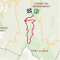

Length
11.9 km

Max alt
1697 m

Uphill gradient
579 m
Km-Effort
19.6 km

Min alt
1179 m

Downhill gradient
578 m
Boucle
Yes
Creation date :
2018-04-17 17:29:39.164
Updated on :
2018-04-17 17:29:39.164
3h17
Difficulty : Unknown

FREE GPS app for hiking
 SityTrail
IGN / Geographical institutes
SityTrail Plus
The world is yours!
About
Trail Other activity of 11.9 km to be discovered at Auvergne-Rhône-Alpes, Drôme, Bouvante. This trail is proposed by JACQUES.FUMAT.
Positioning
Country:
France
Region :
Auvergne-Rhône-Alpes
Department/Province :
Drôme
Municipality :
Bouvante
Location:
Unknown
Start:(Dec)
Start:(UTM)
682473 ; 4978309 (31T) N.
Comments