


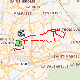
Marseille :de St Barnabé à StJulien par les Caillols

ARPF
User

Length
16 km

Max alt
173 m

Uphill gradient
275 m
Km-Effort
19.5 km

Min alt
50 m

Downhill gradient
237 m
Boucle
No
Creation date :
2018-04-17 17:32:40.886
Updated on :
2018-04-17 17:32:40.886
4h46
Difficulty : Easy

FREE GPS app for hiking
 SityTrail
IGN / Geographical institutes
SityTrail Plus
The world is yours!
About
Trail Walking of 16 km to be discovered at Provence-Alpes-Côte d'Azur, Bouches-du-Rhône, Marseille. This trail is proposed by ARPF.
Description
Là le circuit est au départ de la Fourragère


Positioning
Country:
France
Region :
Provence-Alpes-Côte d'Azur
Department/Province :
Bouches-du-Rhône
Municipality :
Marseille
Location:
5th Arrondissement
Start:(Dec)
Start:(UTM)
695195 ; 4796476 (31T) N.
Comments