


2018_02_Circuit d'Anet

jeanlucien
User
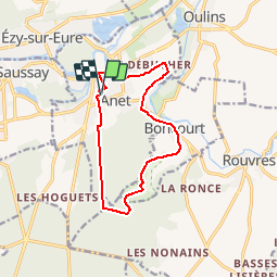

Length
11.1 km

Max alt
139 m

Uphill gradient
201 m
Km-Effort
13.8 km

Min alt
65 m

Downhill gradient
199 m
Boucle
Yes
Creation date :
2018-04-17 17:34:58.753
Updated on :
2018-04-17 17:34:58.753
2h40
Difficulty : Easy

FREE GPS app for hiking
 SityTrail
IGN / Geographical institutes
SityTrail Plus
The world is yours!
About
Trail Walking of 11.1 km to be discovered at Centre-Loire Valley, Eure-et-Loir, Anet. This trail is proposed by jeanlucien.
Positioning
Country:
France
Region :
Centre-Loire Valley
Department/Province :
Eure-et-Loir
Municipality :
Anet
Location:
Unknown
Start:(Dec)
Start:(UTM)
385467 ; 5412373 (31U) N.
Comments