


télésiège le quoi la sur 2018

ARPF
User
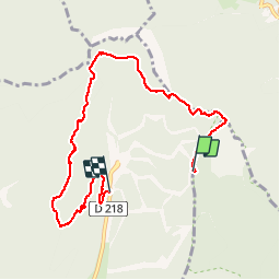

Length
8 km

Max alt
1647 m

Uphill gradient
238 m
Km-Effort
12.3 km

Min alt
1271 m

Downhill gradient
578 m
Boucle
No
Creation date :
2018-04-17 17:41:00.138
Updated on :
2019-11-18 15:42:01.095
4h40
Difficulty : Medium

FREE GPS app for hiking
 SityTrail
IGN / Geographical institutes
SityTrail Plus
The world is yours!
About
Trail Snowshoes of 8 km to be discovered at Auvergne-Rhône-Alpes, Isère, Autrans-Méaudre en Vercors. This trail is proposed by ARPF.
Positioning
Country:
France
Region :
Auvergne-Rhône-Alpes
Department/Province :
Isère
Municipality :
Autrans-Méaudre en Vercors
Location:
Autrans
Start:(Dec)
Start:(UTM)
703600 ; 5011638 (31T) N.
Comments