


etampes chalouette et marette

meillon
User
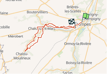

Length
27 km

Max alt
144 m

Uphill gradient
383 m
Km-Effort
33 km

Min alt
77 m

Downhill gradient
396 m
Boucle
No
Creation date :
2018-04-17 17:43:16.337
Updated on :
2018-04-17 17:43:16.337
--
Difficulty : Unknown

FREE GPS app for hiking
 SityTrail
IGN / Geographical institutes
SityTrail Plus
The world is yours!
About
Trail Walking of 27 km to be discovered at Ile-de-France, Essonne, Étampes. This trail is proposed by meillon.
Positioning
Country:
France
Region :
Ile-de-France
Department/Province :
Essonne
Municipality :
Étampes
Location:
Unknown
Start:(Dec)
Start:(UTM)
437819 ; 5365165 (31U) N.
Comments