


vtt Gerbeviller 04-02-18

vathi54
User
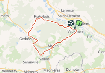

Length
26 km

Max alt
329 m

Uphill gradient
382 m
Km-Effort
31 km

Min alt
232 m

Downhill gradient
382 m
Boucle
Yes
Creation date :
2018-04-17 17:49:31.653
Updated on :
2018-04-17 17:49:31.653
2h20
Difficulty : Unknown

FREE GPS app for hiking
 SityTrail
IGN / Geographical institutes
SityTrail Plus
The world is yours!
About
Trail Mountain bike of 26 km to be discovered at Grand Est, Meurthe-et-Moselle, Vathiménil. This trail is proposed by vathi54.
Photos


Positioning
Country:
France
Region :
Grand Est
Department/Province :
Meurthe-et-Moselle
Municipality :
Vathiménil
Location:
Unknown
Start:(Dec)
Start:(UTM)
324300 ; 5375622 (32U) N.
Comments