


le haut du rouge gazon depuis l'arsenaire

margotte
User
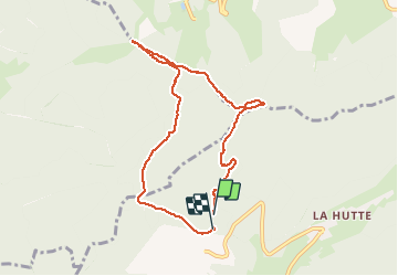

Length
7.6 km

Max alt
1108 m

Uphill gradient
285 m
Km-Effort
11.5 km

Min alt
859 m

Downhill gradient
298 m
Boucle
Yes
Creation date :
2019-06-11 14:15:50.012
Updated on :
2020-04-26 15:28:54.716
2h36
Difficulty : Easy

FREE GPS app for hiking
 SityTrail
IGN / Geographical institutes
SityTrail Plus
The world is yours!
About
Trail Snowshoes of 7.6 km to be discovered at Grand Est, Vosges, Bussang. This trail is proposed by margotte.
Photos


Positioning
Country:
France
Region :
Grand Est
Department/Province :
Vosges
Municipality :
Bussang
Location:
Unknown
Start:(Dec)
Start:(UTM)
340533 ; 5307875 (32T) N.
Comments
Merci pour votre randonnée en raquettes à neige avec photos.