


Tanneron 3

soca
User
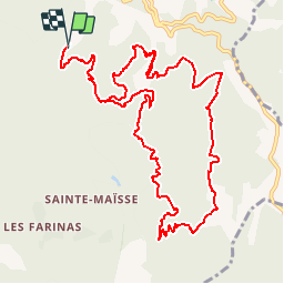

Length
14.8 km

Max alt
493 m

Uphill gradient
599 m
Km-Effort
23 km

Min alt
220 m

Downhill gradient
595 m
Boucle
Yes
Creation date :
2018-04-17 18:07:04.5
Updated on :
2018-04-17 18:07:04.5
4h49
Difficulty : Medium

FREE GPS app for hiking
 SityTrail
IGN / Geographical institutes
SityTrail Plus
The world is yours!
About
Trail Walking of 14.8 km to be discovered at Provence-Alpes-Côte d'Azur, Var, Tanneron. This trail is proposed by soca.
Positioning
Country:
France
Region :
Provence-Alpes-Côte d'Azur
Department/Province :
Var
Municipality :
Tanneron
Location:
Unknown
Start:(Dec)
Start:(UTM)
328237 ; 4827664 (32T) N.
Comments