


08.02.2018 - AMANLIS sud et nord

babeth35
User
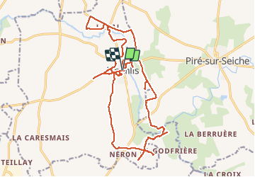

Length
24 km

Max alt
86 m

Uphill gradient
252 m
Km-Effort
28 km

Min alt
28 m

Downhill gradient
253 m
Boucle
Yes
Creation date :
2018-04-17 18:09:40.567
Updated on :
2020-07-20 15:07:27.707
5h58
Difficulty : Easy

FREE GPS app for hiking
 SityTrail
IGN / Geographical institutes
SityTrail Plus
The world is yours!
About
Trail Walking of 24 km to be discovered at Brittany, Ille-et-Vilaine, Amanlis. This trail is proposed by babeth35.
Photos


Positioning
Country:
France
Region :
Brittany
Department/Province :
Ille-et-Vilaine
Municipality :
Amanlis
Location:
Unknown
Start:(Dec)
Start:(UTM)
613674 ; 5318095 (30U) N.
Comments