


La Merindole 13 Lac

Nathy8913
User
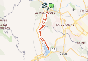

Length
11.6 km

Max alt
201 m

Uphill gradient
235 m
Km-Effort
14.8 km

Min alt
115 m

Downhill gradient
236 m
Boucle
Yes
Creation date :
2018-04-17 18:11:07.645
Updated on :
2018-04-17 18:11:07.645
3h12
Difficulty : Easy

FREE GPS app for hiking
 SityTrail
IGN / Geographical institutes
SityTrail Plus
The world is yours!
About
Trail Walking of 11.6 km to be discovered at Provence-Alpes-Côte d'Azur, Bouches-du-Rhône, Aix-en-Provence. This trail is proposed by Nathy8913.
Positioning
Country:
France
Region :
Provence-Alpes-Côte d'Azur
Department/Province :
Bouches-du-Rhône
Municipality :
Aix-en-Provence
Location:
Unknown
Start:(Dec)
Start:(UTM)
688504 ; 4819419 (31T) N.
Comments
Attention au parking de la tour d'arbois qui est un lieu de drague et de prostitution : https://lieuxdedrague.fr/lieu-de-drague/parking-de-l-arbois/43258