


les Feytaux Terres Blanches 2011-11-01 16h07m48

psesjs
User

Length
9.8 km

Max alt
463 m

Uphill gradient
249 m
Km-Effort
13.1 km

Min alt
352 m

Downhill gradient
249 m
Boucle
Yes
Creation date :
2014-12-10 00:00:00.0
Updated on :
2014-12-10 00:00:00.0
2h09
Difficulty : Easy

FREE GPS app for hiking
 SityTrail
IGN / Geographical institutes
SityTrail Plus
The world is yours!
About
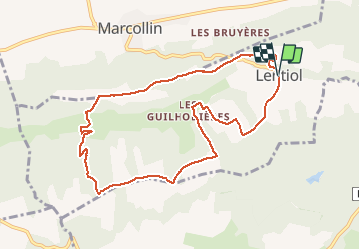
Trail Walking of 9.8 km to be discovered at Auvergne-Rhône-Alpes, Isère, Lentiol. This trail is proposed by psesjs.
Positioning
Country:
France
Region :
Auvergne-Rhône-Alpes
Department/Province :
Isère
Municipality :
Lentiol
Location:
Unknown
Start:(Dec)
Start:(UTM)
665662 ; 5018363 (31T) N.
Comments
ici bathernay
marché très agréable et ombragée en ce temps d ete merci pour le bon plan