


2018-02-10 coudray montceaux

Lucquiaud
User
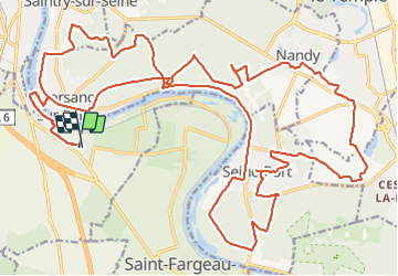

Length
38 km

Max alt
103 m

Uphill gradient
477 m
Km-Effort
44 km

Min alt
31 m

Downhill gradient
478 m
Boucle
Yes
Creation date :
2018-09-15 15:03:05.417
Updated on :
2018-09-15 15:03:05.489
2h50
Difficulty : Unknown

FREE GPS app for hiking
 SityTrail
IGN / Geographical institutes
SityTrail Plus
The world is yours!
About
Trail Mountain bike of 38 km to be discovered at Ile-de-France, Essonne, Le Coudray-Montceaux. This trail is proposed by Lucquiaud.
Description
parcours de la nocturne (dégel et fonte de la neige en cours)
Positioning
Country:
France
Region :
Ile-de-France
Department/Province :
Essonne
Municipality :
Le Coudray-Montceaux
Location:
Unknown
Start:(Dec)
Start:(UTM)
462817 ; 5378943 (31U) N.
Comments