Trail Walking Bagnols-en-Forêt - Bagnols. Pic de la Gardiette 2. - Photo

Bagnols. Pic de la Gardiette 2.

 Sugg
Sugg

User

© OpenStreetMap contributors
Length
Length
14.7 km
Max alt
Max alt
419 m
Uphill gradient
Uphill gradient
439 m
Km-Effort
Km-Effort  
21 km
Min alt
Min alt
248 m
Downhill gradient
Downhill gradient
439 m
Boucle
Boucle
Yes
Creation date :
2019-03-22 16:58:05.822
Updated on :
2019-03-22 16:58:05.879

(0 Reviews)

Walking
Walking
4h32
Difficulty : Medium

Scan this QR Code to open this trail in the SityTrail application

FREE GPS app for hiking

Logo SityTrail SityTrail

IGN / Geographical institutes

Download SityTrail from the App Store Download SityTrail from Google Play

Logo SityTrail SityTrail Plus

The world is yours!

Download SityTrail from the App Store Download SityTrail from Google Play Download SityTrail on Huawei AppGallery

About

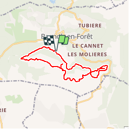
Trail Walking of 14.7 km to be discovered at Provence-Alpes-Côte d'Azur, Var, Bagnols-en-Forêt. This trail is proposed by Sugg.

Description

Rando RF du 14 février 2018.
Départ cimetière, piste de petit Roc, Pic de la Gardiette, contournement par le Sud, GR51, col de la Pierre du Coucou, Anc meulières, La Forteresse, GR51 jusqu'à Bayonne, retour par la piste de la Bayonne, et parking du départ par la citerne.

Elevation profile

Positioning

Country:
France
Region :
Provence-Alpes-Côte d'Azur
Department/Province :
Var
Municipality :
Bagnols-en-Forêt
Location:
Unknown
Start:(UTM)
313453 ; 4822277 (32T) N.


Close
My subscriptions