


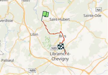
GR151 PoixStH-Spinet

gk@icedd.be
User

Length
22 km

Max alt
574 m

Uphill gradient
591 m
Km-Effort
29 km

Min alt
319 m

Downhill gradient
380 m
Boucle
No
Creation date :
2018-04-17 18:43:00.343
Updated on :
2018-04-17 18:43:00.343
6h07
Difficulty : Unknown

FREE GPS app for hiking
 SityTrail
IGN / Geographical institutes
SityTrail Plus
The world is yours!
About
Trail Walking of 22 km to be discovered at Wallonia, Luxembourg, Saint-Hubert. This trail is proposed by gk@icedd.be.
Positioning
Country:
Belgium
Region :
Wallonia
Department/Province :
Luxembourg
Municipality :
Saint-Hubert
Location:
Hatrival
Start:(Dec)
Start:(UTM)
664163 ; 5543408 (31U) N.
Comments